
My upcoming book treats dominance hierarchy as a core part of how our culture became the way it is. Dominance hierarchies form when there is a necessary resource that can be controlled with no alternative. The first most important such resources have been surplus grains, legumes, and animals that could be domesticated, which largely depend on arable land. Later, as states grew, other such resources were developed, such as education, justice, security, technology, and weapons.
This model predicts that the appearance and durability of tyranny and slavery will depend on arable land. Thus, when I was listening to a podcast on slavery in the state of Arkansas and heard the host ask the guest, an author and professor on slavery, about differences of intensity of the practice of slavery in the state, I suspected the answer had to do with the state’s topography.
My book treats differences in intensity of slavery based on topography in Virginia and Tennessee. Mountainous regions see less slavery, coastal planes and near rivers so more.
The podcast guest’s answer said that if you draw a line from the state’s northeast corner to its southwest, you see greater intensity to the right and below, and less to the left and above. Scroll down for the full answer and link to the orginal.
I was interested in seeing if there was any correlation between her answer and the state’s topography. Here is the first result when I search on Arkansas topography (click any images in this post for higher resolutions):
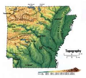
Is it me or is there a clear difference in topography from the northeast to southwest? In particular, the northwest is more mountainous, where it’s more difficult to grow cash crops and to track fugitives.
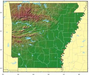
Here’s another topographical map of Arkansas. In case the above map wasn’t clear enough, look how flat the bottom right is.
How about the US in general?
Let’s look at US slavery in general and see how it correlates with topography. Here is a map of the percentage of the population that was enslaved based on the 1860 census.
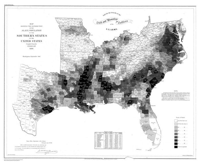
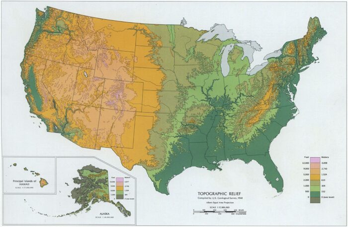
Compare with a topographic map of the US. Many factors affect the distribution and intensity of slavery, but note to correlation with topography. The Appalachian mountains of western Virginia, eastern Tennessee, and adjoining regions support little slavery. The coastal plains and Mississippi River host the greatest density. Meanwhile, the states Pennsylvania northward have less flat land and abolished slavery first.
It’s tempting to believe that people who owned slaves were different than everyone else, but nobody chose where they were born, or into what culture. Every adult is responsible for their actions, so accidents of their birth don’t make them innocent, but if geography plaid a significant role, ending slavery without acknowledging geography would be prone to assuming innate differences between people that didn’t exist, distracting from addressing at least one big root problem.
The relevance to today is that if today’s tyranny correlates with control over necessary resources without alternative, if we attribute traits to others that differ from our own, such as “they don’t care” or “they only care about profit,” will likely exacerbate conflict and distract from solving today’s problems.
From the original podcast
The podcast is The Underview, “a podcast exploring land, people, movement, and belonging in the unsettled Arkansas Ozarks.” The host is Mike Rusch. The episode is: the weary land with Dr. Kelly Houston Jones, part 1, March 2025.
The host asked:
You write in your book this kind of difference between a society with slaves versus slave societies. does this fit within what you’re talking about or is that reference I’m curious the difference between these kind of two framing ideas, if you will.
Here is the guest’s bio:
Professor Kelly Houston Jones, associate professor of history and graduate program director at Arkansas Tech University, specializes in American slavery, usually focusing her research efforts on the Trans-Mississippi South, especially Arkansas. After receiving a BA at the University of Arkansas at Little Rock and an MA at the University of North Texas, Jones earned a PhD from the University of Arkansas in 2014. Since then, she has worked on uncovering the histories of slave life on the ground in Arkansas.
Her first book, A Weary Land: Slavery on the Ground in Arkansas, was published in 2021 by the University of Georgia Press and received the Arkansas Historical Association’s John William Graves Award. Professor Jones carries an enduring interest in the history of Arkansas as the western edge of the American South, which informs her teaching and participation at public history events. She is currently at work on a book manuscript regarding the vigilante murders of enslaved people.
Here is the guest’s answer: I put in what I considered the key parts, stating that slavery intensifies near rivers and to the east and south in the state:
That has been an important tool for us slavery historians. When Ira Berlin coins this set of terms, he’s pointing out the difference between a place where slavery is the fundamental sort of central aspect of that society and economy versus a place where it exists, it’s protected, it’s important, but it’s not the central like fundamental thing and you can apply that to the experience of slavery in Arkansas not without complication, but it can be a handy way to consider, what’s going on. So in a place where, I can maybe, think of it this way. In parts of Arkansas where the plantation system has really taken root along the Mississippi River, the Red River is another, place to look a belt in the Arkansas River for so far, those are places where the system, if you took slavery out of that society and economy, it would be completely unrecognizable.
If you went to even, where I live now, Pope County, they’re growing cotton in the river bottoms, there, but the plantation system is, not the main driver of that economy or that society. Now, I’ve got, there are some qualifications that folks should consider, with that.
One is the sort of blurred line. Where is the line between a society with slaves and a slave society? Those can be hard, okay, to find. And maybe, Some nuance and some blurring is what we need to make room for, and I’ve got, I tried to do that using concepts, of geography in the book to try to help people understand, because in the past, and I, and maybe I haven’t fully succeeded because people still talk about it this way and that’s okay and it’s tempting to draw a line from the northeast corner of Arkansas to the southwest corner and say okay, if it’s to the right and to the bottom of this line, to the east and to the south of this line, then it’s a slave society. If it’s to the north and to the west of this line, it’s a society of slaves.